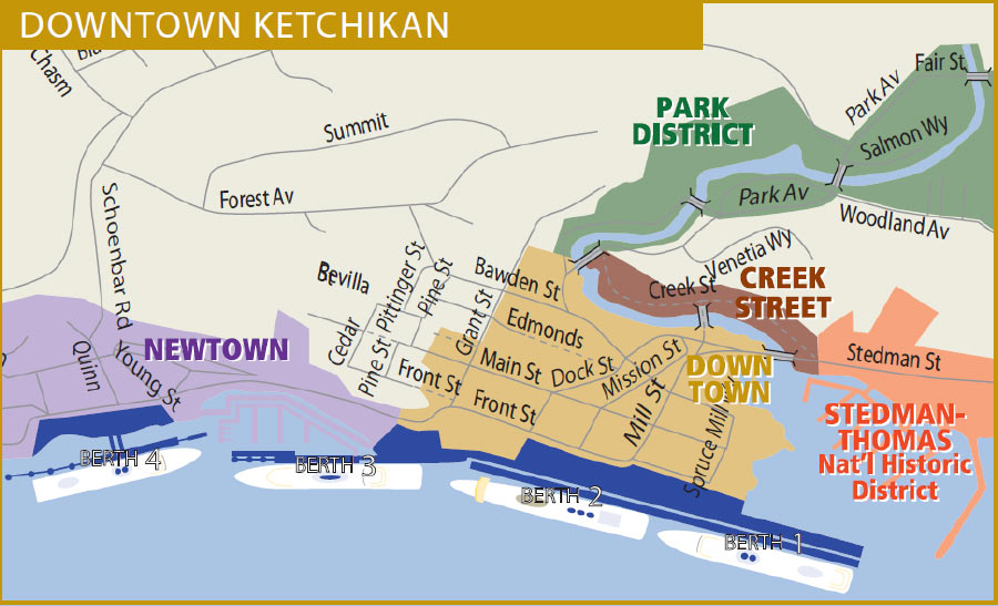
Getting Around: A Map of Ketchikan Alaska
I still remember my first time exploring Ketchikan, and after figuring out the ferry from the airport and arriving downtown, I was struck by how easy it was to navigate! Whether strolling along the waterfront, hopping on a free shuttle downtown, or simply soaking in the sights, I found it effortless to get around and enjoy everything this quirky port city offers. From the historic berths near downtown to the new cruise development of Ward Cove, Ketchikan is as accessible as it is breathtaking, making it the perfect destination for cruisers just looking to navigate for the day.
How Walkable is Downtown Ketchikan?
Ketchikan's downtown area is extremely walkable! The waterfront promenade connects all four cruise ship berths, offering a scenic stroll with breathtaking views of the harbor. From the promenade, you can easily cross Front Street to explore the charming downtown area, full of shops, restaurants, and attractions.
For those arriving at Ward Cove, a shuttle service is available to transport passengers to downtown Ketchikan. The shuttle typically takes about 20 minutes and offers convenient access to the heart of the city.

What Transportation Does Ketchikan Offer?
Ketchikan has a variety of transportation options to suit all needs:
Bus System
Ketchikan boasts an excellent bus system with two main lines operating from May to September:
- The Green Line: Runs from downtown northward, passing the airport ferry.
- The Silver Line: Runs south past Saxman Village to Rotary Beach, then north past Totem Bight State Park.
Additionally, a free 20-minute downtown shuttle loop connects Berth 4 to the Totem Heritage Center. The buses are wheelchair accessible, and fares are affordable at $2 for adults and $1 for children. Click here to visit Ketchikan's transit website.
Taxis and Shuttles
For more flexible transportation, taxis are available throughout Ketchikan. Passengers arriving at Ward Cove can utilize a dedicated shuttle to reach the downtown area, ensuring easy access to the town's main attractions.
Is There Public Parking in Downtown Ketchikan?
If you're driving to Ketchikan, public parking lots are conveniently located in and near the downtown area. A daily parking permit costs $5 and can be purchased at the City of Ketchikan Office Services Division at 334 Front Street. This is a great option for those planning to explore Ketchikan by foot or bus.
With this information, you’re all set to navigate Ketchikan, whether you’re walking downtown, taking a shuttle from Ward Cove, or hopping on the bus to explore further afield.
Sanborn Fire Insurance Map from Ketchikan, Ketchikan Census Division, Alaska. From November of 1914
Cara Lederrman has worked in the Alaskan tourism industry for years, and specializes in sharing her passion for Alaska through blogs and social media content. She travels the Inside Passage each summer to find hidden gems, explore new tours and ensure her recommendations for Alaska tourists are up-to-date.
All of our content at Alaska Shore Tours is written by experienced travel writers who have visited all of the locations we recommend. And our review board of local tourism experts ensure that all the information we provide is accurate, current and helpful